 |
| Gust front "shelf cloud" (or "arcus") on the leading edge of a derecho-producing convective system. The photo was taken on the evening of July 10, 2008 in Hampshire, Illinois as the storm neared the Chicago metropolitan area. The derecho had formed around noon in southern Minnesota. (Courtesy of Brittney Misialek) |
Something we have seen time and time again, particularly on social media, is the confusion that arises when the National Weather Service issues a "Severe Thunderstorm or Tornado WATCH" vs a "Severe Thunderstorm or Tornado WARNING." The two are VERY different! The Storm Prediction Center has provided an excellent FAQ (Frequently Asked Question) section regarding the differences between "watches" and "WARNINGS." We believe everyone should get to know the basics regarding the differences of the two, as well as other severe weather questions that often lead to confusion. We are providing this to you because this information is important, and we think it should be readily accessible to everyone. We can't state enough how many times we have witnessed social media "blow up" with people in a panic over a watch, and worse, more and more people having "arguments" online of what the two terms mean... and what they should do.
In addition, some basic background is provided below as to who the "Storm Prediction Center" is, what they do and what they don't do. There is very good information regarding "Severe Weather Outlooks" below as well... which helps decipher the "Low, Moderate & High" risks for Severe Weather, and what that means to you. We hope this helps clear up some misconceptions, and provides you with the information you need to remain safe, and most importantly calm! Panic during any severe weather is dangerous, and with a little knowledge and preparation, you and your loved ones can remain as safe as possible by learning what the terms mean, and what you should do.
(Please bookmark this page for quick reference)
______________________________________________________________________
What is the Storm Prediction Center?
The Storm Prediction Center (SPC) is one of nine National Centers for Environmental Prediction. Our mission is to provide timely and accurate forecasts and watches for severe thunderstorms and tornadoes over the contiguous United States. The SPC also monitors heavy rain, heavy snow, and fire weather events across the U.S. and issues specific products for those hazards.
Where is the Storm Prediction Center located?
We are located in Norman, Oklahoma.
How does SPC forecast severe weather?
That's a simple question with a complex and ever-changing answer. The ways we make a forecast vary from event to event, as much as the weather itself, and depends on the timing, location and intensity of the hail, thunderstorm wind and tornado threats.
Watch Questions
What is a Severe Thunderstorm or Tornado Watch?
A Severe Thunderstorm Watch outlines an area where an organized episode of hail 1 inch diameter or larger and/or damaging thunderstorm winds are expected during a three to eight hour period. A Tornado Watch includes the large hail and damaging wind threats, as well as the possibility of multiple tornadoes. Typical watches cover about 25,000 square miles, or about half the size of Iowa.
How many watches do you issue in a year?
The SPC issues approximately 1000 watches each year. Of course, the precise number varies from year to year, depending on weather.
Do you issue warnings?
The SPC only issues watches. Your local National Weather Service office issues warnings for your area.
What's the difference between a watch and a warning?
A watch means severe weather is possible during the next few hours, while a warning means that severe weather has been observed, or is expected soon.
Does the SPC issue all severe weather watches and warnings?
The SPC issues all Severe Thunderstorm Watches and Tornado Watches. All warnings are issued locally!
Why are watches not issued for all severe storms?
Many severe thunderstorms affect only a small area for a short period of time, making watches impractical. Watches are issued primarily for areas where well organized or significant severe weather is possible, or the severe weather threat is expected to persist for many hours.
I noticed the wording "THIS IS A PARTICULARLY DANGEROUS SITUATION" in some of your watches. What does this mean? What is the criteria for a PDS watch?
The "particularly dangerous situation" wording is used in rare situations when long-lived, strong and violent tornadoes are possible. This enhanced wording may also accompany severe thunderstorm watches for exceptionally intense and well organized convective wind storms. PDS watches are issued, when in the opinion of the forecaster, the likelihood of significant events is boosted by very volatile atmospheric conditions. Usually this decision is based on a number of atmospheric clues and parameters, so the decision to issue a PDS watch is subjective. There is no hard threshold or criteria. In high risk outlooks PDS watches are issued most often.
Do you forecast hurricanes and tropical storms?
We do not forecast tropical weather. That is done by the National Hurricane Center. We do issue tornado watches for inland portions of tropical cyclones when conditions may develop that favor multiple tornadoes.
What is the watch status line (line with an arrow inside a watch) and how is it interpreted?
When a watch is issued, the original threat is contained within the entire watch area. When the SPC determines where the severe weather threat continues within a severe thunderstorm or tornado watch, usually on an hourly basis, we issue a watch status message. Unless the whole watch area remains valid, the status report includes points on a line that indicates where the severe weather threat remains from our perspective. The severe weather threat is to the right of that line, as in our outlooks. As adjustments are made to the watch, you will see that yellow "status" line shift across the original watch area. This gives emergency managers, weather forecast offices, media and the general public guidance as to where the threat remains for severe weather.
Who clears watches?
It is up to the local NWS forecast offices -- not SPC -- to clear or keep counties within the watch once SPC has issued it. Also, only local NWS offices can cancel a watch. Our status lines are just for guidance purposes to describe the remaining threat area.
What do the watch probability numbers mean? How are these different from outlook probabilities?
Watch and outlook probabilities have different meanings and should not be compared to each other. Probability numbers for watches tell you the chance that a certain kind of severe weather or combination of severe events (say, 2 or more tornadoes, or 6 or more combined severe hail/wind events) will happen in the whole watch. This is much different from outlook probabilities, which describe the chance of severe weather within 25 miles of any point in the outlook.
Watch probabilities are tagged as Low, Moderate or High. This also is different than how the outlook risks are tied to their probability numbers. For watches, the "Low" category contains probability values ranging from less than 2% to 20% (F2-F5 tornadoes), less than 5% to 20% (all other probabilities), "Moderate" from 30% to 60%, and "High" from 70% to greater than 95%.
Outlook Questions
What is this "Z" time that you use all over your outlooks and also in other SPC forecasts?
The time you see on our products is Universal Coordinated Time (UTC) (also known as Greenwich Mean Time (GMT) or Zulu in military parlance -- hence the "Z" abbreviation). We do this for simplicity since the SPC forecast domain covers multiple time zones across the entire 48 contiguous U.S. states, and since all official weather records for scientific use are stored by Z time. It doesn't change with time zone or with daylight versus standard time, so Z makes an efficient and standardized way to communicate a common time reference, no matter where you are. Please visit this link for a conversion table. Another good site to visit regarding the UTC/GMT/Z time and your local time is US Naval Observatory Master Clock Time(Javascript must be enabled).
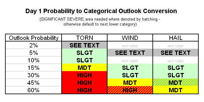
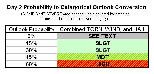
What do the Slight, Moderate, and High risk categories in the Convective Outlook mean?
Slight, moderate and high risks represent progressively larger threat for organized severe storm episodes. These risks and their graphical labels (SLGT, MDT, HIGH) are based directly on the numerical probabilities of severe weather that we provide with every outlook.
What do the outlook probabilities mean?
For the day-1 outlook graphics, the percentage lines enclose the chance that the given type of severe weather (tornado, hail or damaging thunderstorm wind) will happen within roughly a 25 mile radius of any given point inside that line. For Day-2 and Day-3, the probabilities cover all severe storm hazards together. Categorical (SLGT, MDT, HIGH) labels are tied directly to the probability numbers as defined in this table for Day-1, in this table for Day-2 and this one for Day-3 outlooks.
Why do the probability values on the outlooks seem so low?
The probability values represent the chance of severe weather within about 25 miles of a point, which is about the size of a major metropolitan area. Though severe storms tend to receive a large amount of media coverage, severe weather is uncommon at any one location. Your chance of getting a tornado on any random day are very small, climatologically speaking. Put in that context, even a 10% chance of a tornado within 25 miles of a point means a much bigger threat than usual, and should be taken seriously. Think of how often tornadoes normally happen close to you on any given day, and those small-looking probabilities start to seem large by comparison!
What is that nameless green line on Day-1 and Day-2 SPC outlook graphics?
The green line is the general thunderstorm forecast line on the categorical outlook, and represents a 10% or greater probability of thunderstorms to the right of the line. We only do general thunder forecasts for Day-1 and Day-2 outlooks at this time, but may attempt day-3 general thunder forecasts on at least an experimental basis in the future.
General Severe Weather Questions
How does the National Weather Service define severe weather?
There are many forms of hazardous, or severe weather. The primary mission of the National Weather Service is to provide forecasts and warnings for the protection of life and property. Forecasts can range from the climate and seasonal outlooks for agricultural interests provided by the Climate Prediction Center (www.cpc.ncep.noaa.gov), to the daily county forecasts for the public issued by local NWS offices. The NWS issues warnings for heavy snow, freezing rain, high winds, flash flooding, river flooding, thunderstorms, tornadoes, tropical storms, and hurricanes. In a broad sense, these are all defined as severe weather as any of them can and do pose a threat to life and property.
How does the National Weather Service (NWS) define a severe thunderstorm?
The term severe thunderstorm refers to a thunderstorm producing hail that is at least quarter size, 1 inch in diameter or larger, and/or wind gusts to 58 mph or greater, and/or a tornado. Although lightning can be deadly, the NWS doesn't use it to define a severe thunderstorm. If it did, every thunderstorm would be severe, by definition. Also, excessive rainfall may lead to deadly flash flooding, but heavy rain is not a severe criterion either. The flood threat is handled through a separate set of watches and warnings from your local NWS forecast office.
What is organized severe weather and why is it more important than non-organized severe weather?
To some degree, all thunderstorms are organized. We refer to "organized" severe storms as those which persist for several hours, are capable of multiple and/or significant severe weather events, and which we are able to forecast consistently. The most long-lived, intense tornadoes and largest hail are usually produced by supercell thunderstorms, while the most serious convective wind storms are produced by bow echoes. The most serious severe storms tend to form in areas where the vertical wind shear is relatively strong and has particular characteristics, while shorter-lived storms are most common when vertical wind shear is weak.
What environmental parameters are most often observed with organized severe weather?
In general, severe thunderstorms form in areas where moisture, instability, and lift are present. Additionally, long-lived severe thunderstorms are often associated with strong vertical wind shear (e.g., winds that change direction and increase in speed with height). Unfortunately, thunderstorm initiation is not well-understood, and weather observations are too widely spaced to detect all important small-scale features that influence storms.
What is a derecho and where do I learn more about them?
A derecho is an exceptionally long-lived, widespread, severe, convective wind outbreak. Derecho producing storm systems also can contain tornadoes, but they consist mostly of (and are defined by) damaging non-tornadic wind. Sometimes a derecho results in hundreds of severe wind and damage reports spread along a swath covering multiple states, with deaths, injuries and many millions of dollars in losses.
Definition of a derechoA derecho (pronounced similar to "deh-REY-cho" in English, or pronounced phonetically as "
Although a derecho can produce destruction similar to that of a tornado, the damage typically occurs in one direction along a relatively straight path. As a result, the term "straight-line wind damage" sometimes is used to describe derecho damage. By definition, if the swath of wind damage extends for more than 240 miles (about 400 kilometers), includes wind gusts of at least 58 mph (93 km/h) along most of its length, and several, well-separated 75 mph (121 km/h) or greater gusts, then the event may be classified as a derecho.
Strength of derecho windsBy definition, winds in a derecho must meet the National Weather Service criterion for severe wind gusts (greater than 57 mph) at most points along the derecho path. But in stronger derechos, winds may exceed 100 mph. The winds associated with derechos are not constant and may vary considerably along the derecho path, sometimes being below severe limits (57 mph or less), and sometimes being very strong (from 75 mph to greater than 100 mph). This is because the swaths of stronger winds within the general path of a derecho are produced by what are called downbursts, and downbursts often occur in irregularly-arranged clusters, along with embedded microburstsand burst swaths. Derechos might be said to be made up of families of downburst clusters that extend, by definition, continuously or nearly continuously for at least 240 miles (about 400 km).
Those most at risk from derechos
Because derechos are most common in the warm season, those involved in outdoor activities are most at risk. Campers or hikers in forested areas are vulnerable to being injured or killed by falling trees. People at sea risk injury or drowning from storm winds and high waves that can overturn boats.
Because derechos are most common in the warm season, those involved in outdoor activities are most at risk. Campers or hikers in forested areas are vulnerable to being injured or killed by falling trees. People at sea risk injury or drowning from storm winds and high waves that can overturn boats.
Occupants of cars and trucks also are vulnerable to being hit by falling trees and utility poles. Further, high profile vehicles such as semi-trailer trucks, buses, and sport utility vehicles may be blown over. At outside events such as fairs and festivals, people may be killed or injured by collapsing tents and flying debris.
Even those indoors may be at risk for death or injury during derechos. Mobile homes, in particular, may be overturned or destroyed, while barns and similar buildings can collapse. People inside homes, businesses, and schools are sometimes victims of falling trees and branches that crash through walls and roofs; they also may be injured by flying glass from broken windows. Finally, structural damage to the building itself (for example, removal of a roof) could pose danger to those within.
Another reason that those outdoors are especially vulnerable to derechos is the rapid movement of the parent convective system. Typically, derecho-producing storm systems move at speeds of 50 mph or greater, and a few have been clocked at 70 mph. For someone caught outside, such rapid movement means that darkening skies and other visual cues that serve to alert one to the impending danger (e.g., gust front shelf clouds ) appear on very short notice. In summary, the advance notice given by a derecho often is not sufficient for one to take protective action.
Special hazards posed by derechos in urban areas
Whether in an urban or rural area, those out-of-doors are at greatest risk of being killed or injured in a derecho. But of particular significance in urban areas is the vulnerability of electrical lines to high winds and falling trees. In addition to posing a direct hazard to anyone caught below the falling lines, derecho damage to overhead electric lines sometimes results in massive, long-lasting power outages. Hundreds of thousands of people may be affected; in the worst events, power may not be restored for many days.
It is the complex and dense concentration of overhead distribution feeders in urban areas --- and their frequent proximity to large trees --- that make cities especially vulnerable to electrical outages following wind storms. The density and mileage of overhead electric distribution lines in urban areas far exceeds that of any rural or exurban area. Pole lines often carry multiple circuits and voltages, as well as lines for street lighting and customer service connections that further add to the vulnerability. Because of this, and because urban electrical feeders typically serve smaller territories relative to their rural counterparts, significantly greater manpower is necessary to restore service after major storms. In addition, unlike the localized damage produced by a tornado, derecho damage may be widespread. As a result, repairs often require greater effort, with additional delays related to shortages in supplies.
DERECHO-PRODUCING STORMS
Derechos are associated with bands of showers or thunderstorms (collectively referred to as "convection") that assume a curved or bowed shape. The bow-shaped storms are called bow echoes. Bow echoes typically arise when a storm's rain-cooled outflow winds are strong, and move preferentially in one direction.
A derecho may be associated with a single bow echo or with multiple bows. Bow echoes, in turn, may consist of an individual storm, or may be comprised of a series of adjacent storms (i.e., a squall line or, more formally, a quasi-linear convective system) that together take on a larger scale bow shape. Bow echoes may dissipate and subsequently redevelop during the course of given derecho. Derecho winds occasionally are enhanced when a rotating band of storms called a bookend vortex develops on the poleward side of the bow echo storm system. Derecho winds also may be augmented by the presence of embedded supercells (rotating thunderstorms) and other smaller-scale circulations in the derecho-producing convective system.
As noted previously, derecho winds are the product of what meteorologists call downbursts. A downburst is a concentrated area of strong wind produced by a convective downdraft. Downbursts have horizontal dimensions of about 4 to 6 miles (8 to 10 kilometers), and may last for several minutes. The convective downdrafts that comprise downbursts form when air is cooled by the evaporation, melting, and/or sublimation (the direct change to vapor phase) of precipitation in thunderstorms or other convective clouds. Because the chilled air is denser than its surroundings, it becomes negatively buoyant and accelerates down toward the ground. Derechos occur when meteorological conditions support the repeated production of downbursts within the same general area. The "downburst clusters" that arise in such situations may attain overall lengths of up to 50 or 60 miles (80 to 100 kilometers), and persist for several tens of minutes. Within individual downbursts there sometimes exist smaller pockets of intense winds called microbursts. Microbursts occur on scales (approximately 2 1/2 miles or 4 km) that are very hazardous to aircraft; several notable airline mishaps in recent decades resulted from unfortunate encounters with microbursts. Still smaller areas of extreme wind within microbursts are called burst swaths. Burst swaths range from about 50 to 150 yards (45 to 140 meters) in length. The damage they produce may resemble that caused by a tornado.
(All information was gathered from the National Weather Service / Storm Prediction Center)
No comments:
Post a Comment