Current Watches, Warnings and Advisories for New Jersey Issued by the National Weather Service

Wednesday, July 16, 2014

JERSEY WEATHERGUYS PROVIDES NJ / NY WITH 2 HOURS ADVANCED WARNINGS

WHY YOU NEED THE JERSEY WEATHERGUYS:  100% ACCURACY WITH 2-4 HOURS ADVANCED NOTICE GIVEN!

If you are curious as to how effective the Jersey Weathguys accuracy rate is, and how much advanced notice you may obtain IN ADVANCE of Severe Weather, the following data demonstrates the skill of our team, the accuracy of detecting potentially damaging storms and the ability to detect storm intensification scientifically and report those findings immediately with the goal of protecting lives and property.  A special thank you to Bob Burger, Chris Aldrich and Dave Jonaitis for their efforts as well during the storm outbreak between July 13th through July 15th.   Here are the important Storm-By-The-Numbers (SBTN) for this particular outbreak:

July 13th, 2014

At 6:30PM, and again at 6:53PM, the Jersey WeatherGuys (JWG) issued a Severe Weather Alert for a potential Severe Thunderstorm that would affect Western NJ.  At 10:27PM, the National Weather Service (NWS) in Mount Holly, NJ issued a Severe Thunderstorm Warning… JWG provided nearly 4 hours advance notice on this storm.


July 14th, 2014

At 3:57PM, JWG posted an advisory for a possible Severe Thunderstorm with rotation observed in the wall clouds that formed.   At 4:21PM, the NWS issued a Severe Thunderstorm Warning for this storm.   JWG provided approximately 25 minutes advanced warning on this particular cell.

At 6:26PM, the JWG posted an “Area of Concern” regarding a potentially damaging storm cell developing in Maryland.  Based on that particular storm’s history, it’s trajectory and prior Tornado Warning… JWG issued an alert for most of South and Central Jersey.  At 7:03PM, the NWS issued a Severe Thunderstorm Warning for Salem County for that same storm.  The warnings were further extended into Glouster/Camden Counties (7:29PM) and Burlington/Camden Counties (7:53PM) and finally Ocean/Monmouth at 8:36PM.  Most importantly, this same storm line became Tornado Warned in Burlington County at 8:19PM!   Jersey WeatherGuys provided nearly 2 HOURS ADVANCED WARNING on the Tornado Storm Line… and between 1/2 hour - 2 hours advanced notice for this severe storm line for most of Southern/Central Jersey!

July 15th, 2014

At 1:30PM, the Jersey WeatherGuys issued an initial alert for a line of storms that were increasing in intensity, and appeared to be ramping up to severe status.  Again at 1:50PM, the JWG issued an additional alert for this same line of storms.  The National Weather Service issued Severe Thunderstorm Warnings for multiple counties including Mercer, Middlesex, Monmouth, Ocean and Burlington at 2:29PM and 2:30PM.  Jersey WeatherGuys provided over 1 hour advanced warning of this line of storms for all of the Counties listed in the Severe Thunderstorm Warning areas.

At 3:10PM, the JerseyWeatherGuys observed and reported an Area of Concern for Southern NJ… a line of thunderstorms that appeared to be intensifying on Doppler Radar.  At 3:42PM, the National Weather Service issued a Severe Thunderstorm Warning for Counties in South Jersey for that same line of storms (Salem/Glouster).  Jersey WeatherGuys provided over 1/2 hour advanced warning for that line of storms.

At 4:03PM, the Jersey WeatherGuys provided a detailed analysis of another Area of Concern for a line of storms that appeared to be intensifying and heading into a highly populated region of NJ (Middlesex, Mercer, Ocean, Monmouth and Burlington Counties).  At 4:55PM and again at 5:11PM, the National Weather Service issued a Severe Thunderstorm Warning for Middlesex, Somerset, Mercer, Morris and Hunterdon Counties.  The Jersey WeatherGuys provided approximately 45 minutes advanced warning for these areas.  At 5:16PM and again at 6:11PM, the National Weather Service extended those Warnings to Coastal Ocean and Monmouth Counties.   The Jersey WeatherGuys provided ONE TO TWO HOURS advanced notice for those counties.


This is in addition to several hours advanced notice of Flash Flood Warnings that were issued for multiple counties in NJ between 7/14/14 - 7/15/14 as well as a few notices published for NYC and Long Island with a minimum of 30 minutes advanced notice.

Data Source:  National Weather Service Mount Holly.
Jersey WeatherGuys Severe Weather Forecaster: GSL / OCNJ009

Verified:  July 16, 2014

Monday, July 14, 2014

SEVERE WEATHER UPDATE FOR MONDAY, JULY 14th, 2014: NJ, NY, PA, CT, MD, VA

*** SEVERE WEATHER UPDATE:  IMMEDIATE RELEASE, MONDAY, JULY 14th, 2014 ****


Looking at our weather map, we see the double-low pressure systems sitting over Michican and Illinois… those will be moving down through Indiana, Ohio and tracking in an Easterly direction towards NJ later today and tonight….

Behind those lows, are nice COOL temperatures…. the air mass is from Canada, and as such, is pulling in temperatures that will only hit the 60’s over much of the mid-west over the next few days.

Those low temperatures WILL NOT hit  NJ…. as we will stay fairly warm, particularly today and tomorrow….
Looking around NJ temps are safely in the 80’s in most places:

81 in Ringwood, 86 in New Brunswick, 85 in Toms River, 87 near Cape May and a bit coller along the Shore, most temperatures in the upper 70’s to low 80’s…

Looking at the Radar…. not much happening currently around the state, although we did have some small pop-up showers around Ocean County, particularly between Toms River and Point Pleasant areas… Some showers are moving in to the NW portion of NJ near Sussex County… but most of the heavy rain and thunder activity still remains off to our west, but storms are now popping up around Lancaster, PA…. this will likely be there pattern during the early afternoon as we see our daytime temperatures interact with an already unstable atmosphere…

Let’s talk about the severe weather that we are expecting, because it is very real concern for the next two to three days….

The cold-fronts pushing down from the Michigan / Illinois area will slowly make its way down from the north and push east… as it does so…. it is going to interact with the already hot and humid air that is sitting over much of the Mid-Atlantic region, including NJ.  This will happen slowly…. taking a few days to finally push through.

As the fronts come through, the unstable air sitting over NJ will easily trigger off thunderstorms, many of which will hit severe levels quickly.  Remember severe thunderstorms require winds over 57mph, hail or tornadoes… all of which are very real possibilities today, Tuesday and even part of Wednesday… at least until early morning wednesday….

The National Weather Service in Mount Holly, NJ has already issued a Flash Flood Warning for most counties of NJ, particularly those along the delaware river, but also including Middlesex and western Monmouth Counties…. Flash Floods can happen quickly, and NJ is in a favorable position for Flash Floods to occur as rainfall amounts of 1-2” per hour are possible during any of the thunderstorms fired up later today and tomorrow.   


Looking at the potential rainfall amounts, not much has changed since our update on Sunday…. most areas of NJ are still well within the 2”-4” range over a 24 hour period starting this afternoon, and that will continue again on Tuesday… possibly Wednesday.  We are talking significant amounts of rain in a short amount of time… which may easily overwhelm small rivers and streams as well as over saturating the ground.

That brings us to the other problem which will be wind… high winds that come with any of thee more severe thunderstorms won’t have much problem taking down large trees if the ground becomes saturated quickly… we will all need to be particularly cautious later today during any severe thunderstorms, and as a general precaution, stay away from windows and under trees when possible as falling trees do kill people every year.


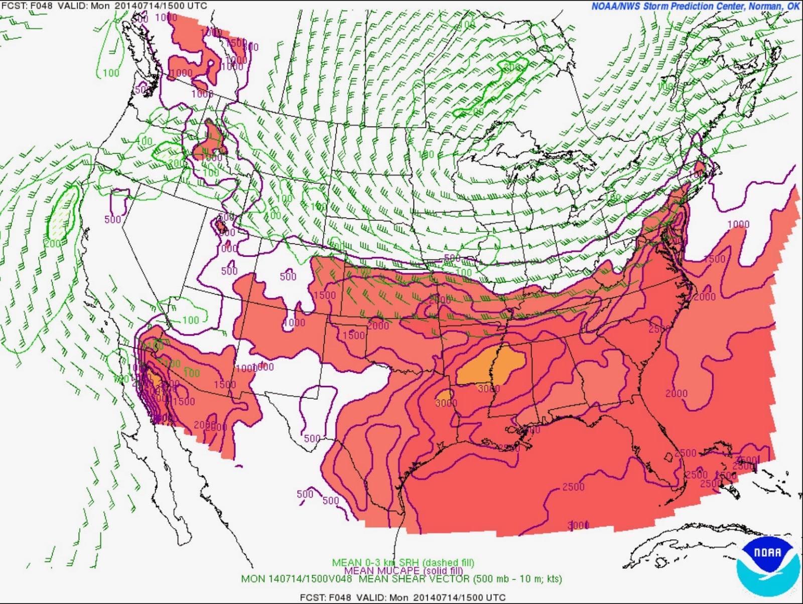
Looking at Severe Weather Risks… the Storm Prediction Center in Oklahoma has placed all of NJ in the “Slight Risk Category” which means conditions are very much favorable to severe weather including Severe Thunderstorms which come with high winds, hail and even a possible Tornado… there is AMPLE energy… to the tune of 1500 - 2000Joules/kg in our atmosphere right now… and again, it will take very little to trigger off thunderstorms today, tomorrow into early Wednesday…  This is a particularly charged atmosphere, and we want to caution everyone that significant weather is possible today and Tuesday….  On Tuesday, pretty much the same set up as today… with generally southern NJ being in the crosshairs for possible severe weather… again, all of NJ will be seeing rain and thunderstorms Tomorrow… so no break in the action there….

Things should start to stabilize by mid-day wednseday … but we are looking ahead to Friday where Severe Weather and more Hot/Humid air comes back to NJ…

For now… be aware that severe weather can occur at any time after 2PM today… we will broadcast updates as usual on our social media sites such as Facebook at JerseyWeather Guys, and Twitter at NJWeatherGuys…. 


Sunday, July 13, 2014

SEVERE WEATHER BEGINS IMPACT ON NORTHEAST / MID-ATLANTIC 7/13/14

Arriving just a little ahead of schedule, and with a bit of a punch, an elongated line of Severe Thunderstorms and several Tornado Warnings impacted many areas surrounding State College, PA region.

At 8:45PM, we are still watching this line of storms which has had a history of fairly widespread wind damage generally including trees being blown down.  One storm report included a rainfall rate of 1" in 20 minutes, or the equivalent of 3-inches per hour.  A tornado warned storm also is tracking eastward out the Virginia region towards NJ... and we are watching these lines carefully.

A Severe Thunderstorm Watch was posted by the NWS at 7:50PM for much of the western portion of NJ with Warnings likely by 9:00PM.  Stay tuned as we cover the first of what is likely to be many Severe Thunderstorms over the next 48-72 hours.


SEVERE WEATHER ALERT FOR NJ: MONDAY, JULY 14th 2014


*** SEVERE WEATHER ALERT FOR NJ, NY, PA, CT, VA, DE, MD, WV, OH, TN ***


NJ IS OUTLOOKED FOR SEVERE WEATHER ON MONDAY, JULY 14th, 2014

This is a Severe Weather Update for all of NJ, including surrounding areas of NY and PA.  Severe Thunderstorms will be possible primarily across parts of the Ozarks, the lower Ohio Valley, Tennessee Valley and Mid-Atlantic states / Southern New England on Monday.


Video Link: https://www.youtube.com/watch?v=uKzo-n1Dw98&feature=youtu.be


Amplification of the large-scale upper air pattern will occur on Monday as a seasonably strong upper level tough becomes established from Ontario/Quebec southward across the Great Lakes and Ohio Valley.  A series of impulses over the Pacific Northwest / Norther Rockies will move East-SouthEastward at the crest of a ridge of high pressure centered over the Great Basin.  A pronounced cold front will extend from the lower Great Lakes across the Southern Plains while a pre-existing surface frontal boundary, reinforced by prior convective outflows will be in place in advance of the front from southern New England southwestward into portions of the Ohio Valley and Ozarks.

Showers and thunderstorms will likely be present along the pre-existing front/outflow boundary early Monday and will likely influence subsequent thunderstorm development later in the day.  However, and increase in thunderstorm coverage is expected with afternoon heating along both the southwestward surging cold front and the pre-existing boundary.  The presence of strengthening wind fields and heating of a moist boundary layer with upper 60’s / lower 70’s dew-points will provide a favorable environment for organized multi cells and line segments capable of damaging winds.

The “Slight Risk” area was extended northwestward across New England where 35-40KTS of shear will be present by the afternoon and heating of lower 70’s dew-points will support MLCAPE of 1000-1500J/kg.  Damaging winds are also likely with thunderstorms along the frontal boundary in this area.  Both the NAM and GFS guidance depict somewhat stronger low-level winds associated with a weak surface low that may result in at least some risk for a tornado with any semi-discrete thunderstorm.

As always, you can find active weather alerts here at www.JerseyWeatherGuys.com as well as on Twitter at @NJWeatherGuys ... Stay tuned as there will likely be frequent updates to this forecast... while severe weather is not imminent, conditions are favorable during the Monday morning/afternoon timeframe through Tuesday, July 15th.  In addition to severe weather, flooding may become a big issue for NJ as precipitation in the amounts of 2"-4" is forecast for most of NJ and NYC / Long Island northeast through New England.

Saturday, July 12, 2014

SEVERE WEATHER DISCUSSION FOR MONDAY, JULY 14TH, 2014

*** SEVERE WEATHER DISCUSSION FOR MONDAY, JULY 14, 2014 ***

HAVING REVIEWED THE SPC FORECAST GUIDANCE PRODUCTS, THERE APPEARS TO BE AT MODERATE RISK FOR SEVERE WEATHER ON MONDAY, 7/12/14.  NJ HAS BEEN OUTLOOKED BY THE STORM PREDICTION CENTER FOR MONDAY UNDER “SLIGHT RISK” AS WELL, AND THEREFORE, THIS IS BEING PUBLISHED FOR YOUR GUIDANCE.  AS OF TODAY, SATURDAY, THE SPC GUIDANCE SUGGESTS MOST UNSTABLE CAPE VALUES OF AT LEAST 1000J/KG AND UP TO 2000J/KG AT LEAST OVER CENTRAL AND WESTERN NJ, EXTENDING INTO SOUTHWEST AND COASTAL NJ AS THE DAY GOES ON.


SHEAR/CAPE EXIST FOR SUPERCELL DEVELOPMENT FROM A PERIOD STARTING MONDAY MORNING AROUND 11AM LASTING THROUGH TUESDAY 11AM (ACTUAL TIMES WILL LIKELY BE ADJUSTED PRIOR TO MONDAY). WE ARE ISSUING THIS GUIDANCE TODAY DUE TO THE NATURE OF THE DOUBLE COLD FRONT AND THE POSSIBILITY THAT THE POTENTIAL SEVERE WEATHER THREAT COULD POTENTIALLY INCREASE, OR DECREASE, DEPENDING ON HOW MUCH HEAT IS AVAILABLE ON MONDAY.  HERE IS THE OFFICIAL TEXT FROM THE SPC AND NWS FOR THE NJ/PHI AREA:


A TROUGH OF SUBSTANTIAL AMPLITUDE WILL EVOLVE ACROSS THE UPPER MS VALLEY AND GREAT LAKES REGIONS THROUGH MONDAY WITH THE GREATEST MID-LEVE HEIGHT FALLS OF 60-90M PER 12H FORECAST TO SPREAD FROM MN/WI TO MI/OH/INDIANA DURING THE PERIOD. A STRONG COLD FRONT ASSOCIATED WITH THE AMPLIFYING TROUGH IS FORECAST TO SPREAD EAST-SOUTHEAST FROM THE UPPER MIDWEST TO THE MIDDLE MS VALLEY THROUGH THE PERIOD WITH CYCLOGENESIS POSSIBLE ALONG THE FRONT OVER THE EASTERN GREAT LAKES...PER LATEST ECMWF (THIS REFERS TO THE MUCH DEBATED “POLAR VORTEX” OF JULY). 

THE FORECAST IS MADE MORE COMPLEX GIVEN A MORE DIFFUSE FRONT FROM NEW ENGLAND TO THE MID-ATLANTIC WILL PRECEDE THE STRONGER COLD FRONT...AND THERE ARE MODEL DIFFERENCES AS TO THE STRENGTH AND TIMING OF CYCLOGENESIS ALONG THE TRAILING FRONT...AND THE DEGREE OF AIRMASS DESTABILIZATION THAT WILL TAKE PLACE ALONG/NEAR BOTH BOUNDARIES AND THE DEVELOPING FRONTAL LOW.

MID MISSISSIPPI VALLEY TO NJ/PA/NY AND NORTHERN DELMARVA AREAS… GIVEN THE AFOREMENTIONED FORECAST COMPLEXITIES ONLY A BROAD ZONE OF RELATIVELY LOW SEVERE PROBABILITIES CAN BE DEPICTED IN THIS OUTLOOK. THE LEADING FRONT WILL BE INTERSPERSED WITH CONVECTIVE OUTFLOW…AND LIKELY ONGOING STORMS...THAT SHOULD SPREAD EAST NORTHEAST INTO A CORRIDOR OF INCREASING INSTABILITY. SHEAR AND FORCING AS DEPICTED IN BOTH NAM AND PARALLEL NAM...AS WELL AS GFS AND ECMWF...WOULD SUPPORT A FEW TO SEVERAL ORGANIZED STORMS WITH STRONG TO DAMAGING WINDS AND ALSO SOME TORNADO POTENTIAL. 


FOR NJ / PA SPECIFICALLY, ON MONDAY, THE ENTIRE EASTERN SEABOARD WILL BE POSITIONED WITHIN THE PRE-FRONTAL WARM SECTOR THAT IS WELL AHEAD OF THE GREAT LAKES UPPER LOW AND ATTENDANT COLD  . HOT AND HUMID ARE FORECAST WITH SLY RETURN FLOW AROUND THE HIGH AND THE LLVL THERMAL RIDGE OVERHEAD. HOWEVER, THE EXTENT OF LEFTOVER DEBRIS CLOUDS FROM OVERNIGHT CONVECTION IS UNCERTAIN, BUT IF CLOUDS LINGER LATER INTO THE DAY THAN CURRENTLY ANTICIPATED, FORECAST MAX TEMPS IN THE LOWER 90S MAY NOT BE REALIZED. ASSUMING SUFFICIENT BREAKS IN CLOUD COVER DO OCCUR, MODERATE TO STRONG INSTABILITY WOULD DEVELOP OVER THE REGION (MEDIAN SBCAPE FROM THE 09Z SREF ARE 1500-2000 J/KG) WOULD LIKELY DEVELOP ALONG A SHARPENING LEE SFC TROUGH DURING THE AFTERNOON. STRONGER SW WINDS ALOFT WILL SPREAD EASTWARD AHEAD OF THE TROUGH, HELPING TO INCREASE DEEP-LAYER SHEAR OVER THE AREA (FCST MEDIAN 0-6 KM SHEAR FROM THE 09Z SREF INCREASES TO 40 KT ACROSS NERN PA LATE IN THE DAY). THERE IS A POTENTIAL FOR SEVERE THUNDERSTORMS MONDAY AFTERNOON AND EVENING GIVEN THE FORECAST ENVIRONMENT. THE AREA IS OUTLOOKED IN A SLIGHT RISK BY SPC FOR MONDAY. DAMAGING WINDS WOULD BE THE PRIMARY THREAT BUT LARGE HAIL, ISOLATED TORNADOES AND FLASH FLOODING ARE ALSO POSSIBLE.

APPROACHING COLD FRONT ON SUNDAY 8PM
FRONTAL BOUNDARY / PRECIPITATION APPROXIMATELY 8AM IN NORTHWEST NJ... A BIT LATER FOR CENTRAL/SOUTHERN NJ.... TIMES MAY CHANGE PRIOR TO MONDAY 7/14/14

POLAR VORTEX: FACTS AND FICTION FROM THE NATIONAL WEATHER SERVICE (NY) 7/12/2014

Many of you may have heard that the Polar Vortex will be making a comeback next week. We thought that this might be a good time to remind everyone what the Polar Vortex is and isn’t through this informational graphic. The most basic definition is that it is a piece of energy that comes from the polar region. It is generated by the large difference in temperature between the tropics and the poles. The temperature gradient is strongest during the winter; therefore it is more likely to affect mid latitudes (our area) in the winter. However, it can affect us in the summer, but it is not nearly as strong as it is in the winter. The Climate Prediction Center is forecasting a 40%-50% chance of below normal temperatures for our area, while they are forecasting an 80%-90% chance of below normal temperatures for the mid-west. Because it is summer, the cool air mass will moderate quickly and the temperatures here are not expected to be as cool as what is forecast in the mid-west. Temperatures here will likely be just slightly below normal, but keep checking back with us for updates!


THANK YOU to our friends at the NWS NY for putting out this very simple to understand graphic regarding the "Polar Vortex."  This is the best way to describe it, and ensures everyone that we stand behind the science of Meteorology.  The "Polar Vortex" took on a life of its own during the winter of 2013-2014 for unknown reasons (probably just because of the shear volume of cold days due to the phenomenon) however, it's now summer... we won't see the next ice-age due to this Polar Vortex... but we will see some rather unpleasant weather starting Monday, July 14th... we hope this info-graphic helps everyone understand what it is, what it isn't, and more importantly, what NOT to fear when they hear the term in July.  We will be posting our severe weather updates as the cold air mass starts to make its way south and east into the region later this weekend/early start of the work week.

Friday, July 11, 2014

POLAR VORTEX: IN JULY???

Some of you may have already heard the news, but some have not.  There has been a lot of confusion (after this past winter) regarding the new term "Polar Vortex."  In fact, the phenomenon known as a "Polar Vortex" is not new at all... it's been around for a long long time.

So what is a "Polar Vortex" and how can it happen in July?

Briefly, the "Polar Vortex" is nothing more than the cooler Canadian air mass (in the Northern hemisphere) that generally resides around the top (North) of our planet.  It generally sits up there nicely and is responsible for the much colder temperatures that our neighbors to the North usually experience.  Here is a bit more detail on the trendy Polar Vortex we all have come to dread this past winter  (See below for the current Polar Vortex forecast):

"‘Polar vortex’ is the new buzzword of 2014 for the millions of Americans learning about its role in producing record cold temperatures across the country. Meteorologists have known for years that the pattern of the polar vortex determines how much cold air escapes from the Arctic and makes its way to the U.S. during the winter. Now climate scientists want to know if a warmer Arctic is influencing its behavior.

Maps show the 500-millibar geopotential height (the altitude where the air pressure is 500 millibars) on January 5, 2014 (left), and in mid-November 2013 (right). The cold air of the polar vortex is purple. Maps by NOAA Climate.gov, based on NCEP Reanalysis data from NOAA ESRL Physical Sciences Division.


The polar vortex is a high altitude low-pressure system that hovers over the Arctic in winter. When the polar vortex is strong, it acts like a spinning bowl balanced on the top of the North Pole. The image on the right shows a strong phase of the polar vortex in mid-November 2013. Dark purple depicts the most frigid air tightly contained in an oval-shaped formation inside the invisible bowl. The light purple line forming the outermost boundary of the cold Arctic air is the jet stream in its normal west-to-east pattern.
In early January, the polar vortex weakened and broke down, allowing fragments of cold air to slosh out of the bowl into mid-latitudes. The image on the left shows the weakened vortex formation on January 5, 2014. The high pressure building up in the Arctic slowed down the jet stream, which caused it to buckle into deep folds and flow farther south than usual, introducing cold Arctic air into the central and eastern U.S.
In recent years, climate scientists have noticed that the jet stream has taken on a more wavy shape instead of the more typical oval around the North Pole, leading to outbreaks of colder weather down in the mid-latitudes and milder temperatures in the Arctic, a so-called “warm Arctic-cold continents” pattern. Whether this is normal randomness or related to the significant climate changes occurring in the Arctic is not entirely clear, especially when considering individual events. But less sea ice and snow cover in the Arctic and relatively warmer Arctic air temperatures at the end of autumn suggest a more wavy jet stream pattern and more variability between the straight and wavy pattern.
Understanding the connections between the Arctic warming trend and more severe weather in the mid-latitudes remains an active area of research. But even as Earth’s average temperature rises, natural patterns of climate variability are expected to still operate in a warmer world. There have been many other cases of natural climate oscillations influencing our winter weather in recent years. The unusually cold winter of 2009-2010 proved that record-breaking snowstorms can still coexist with global warming, as did the frigid start to 2011, which resulted in another wintry winterfor the eastern United States."
JULY 2014 "POLAR VORTEX" FORECAST:
MUCH COLDER THAN NORMAL TEMPERATURES EXPECTED OVER THE CENTRAL US DUE TO SAGGING COLD AIR FROM CANADA ... JULY 11th - JULY 20th 2014

Synopsis: A strong cold front is expected to move from the Great Lakes to the East Coast at the beginning of this period. Behind the front, cool high pressure is forecast to bring below normal temperatures to most of the eastern half of the Lower 48. In the Intermountain West, high pressure is forecast to prevail, favoring warmer temperatures.

Hazards
  • Much above-normal temperatures for parts of the Great Basin and Northern Intermountain West, Mon-Fri, Jul 14-18.
  • High winds for northwest Alaska, Tue-Wed, Jul 15-16.
  • Heavy rain for northwest Alaska, Wed, Jul 16.
  • High winds for the Aleutians and southwestern coast of Alaska, Wed-Thu, Jul 16-17.
  • Severe weather for parts of the Mississippi and Ohio Valleys and the Mid-Atlantic, Mon, Jul 14.
  • Heavy rain for parts of the southern Rockies, Ohio and Tennessee Valleys and the Northeast, Mon-Tue, Jul 14-15.
  • Heavy rain for coastal portions of the Carolinas and southern Plains, Wed-Thu, Jul 16-17.
  • Flooding occurring or imminent for parts of North Dakota and the Middle Mississippi Valley.
  • Severe drought for parts of the Great Plains, Southwest, Pacific Northwest, Great Basin, and California.
Detailed Summary

For Monday July 14 - Friday July 18: The first part of this forecast period is expected to feature an amplified upper-level trough across the Great Lakes region. As this trough amplifies, a surface cold front is predicted to move from the Upper Midwest to the Southeast. As it makes its way towards the East Coast, warm, moist air in advance of the front coupled with an upper-level jet streak is expected to set the stage for a severe weather outbreak from eastern Pennsylvania to northeast Arkansas. However, based upon where the greatest amounts of atmospheric moisture are expected to be, the greatest chances for heavy rain include the Tennessee Valley and New England on Monday and Tuesday, the 14th and 15th. Because the cold front is forecast to linger along the coastal Carolina region, this part of the country is expected to receive heavy rain from Monday the 14th through Thursday the 17th. 

The cold front is forecast to stretch from the East Coast back to the Rockies as high pressure is expected to be situated over the northern and central Plains. The combination of upslope flow and the focus of precipitation associated with the front, heavy rain is anticipated for parts of the southern Rockies. With rainfall totals of more than 2 inches predicted over high terrain, localized flash flooding is possible as well. 

In addition, an upper-level ridge is forecast to amplify in the western states, favoring much above normal temperatures in parts of the Pacific and Intermountain West, with daily maximum temperatures 12 to 20 degrees above normal possible throughout this entire forecast period. 

An upper-level shortwave currently in the eastern Pacific is forecast to rotate around the western ridge axis and move into the southern Plains. The divergence associated with this shortwave, combined with northwest flow, makes conditions favorable for the formation of a mesoscale convective system. Thus, a heavy rain hazard is indicated on the map for parts of Oklahoma and Texas on the 16th and 17th, with severe weather also possible. 

In Alaska, a large closed upper-level low slowly rotating near the Aleutians is expected to be the impetus for unsettled weather. Towards the end of this period, the low is forecast to open up and move into the state. The associated surface low is predicted to move parallel to the Aleutians and bring high winds of 30-40 knots to the islands as well as the southwestern coast. In addition, a separate upper-level shortwave is forecast to move east from northern Russia. It is expected to bring high winds of at least 30 knots to the North Slope from the 15th to the 16th. Heavy rain is also possible with totals of 1 inch or more on the 16th. Because this part of the state is very dry this time of year, significant impacts from this storm could occur. Some models are forecasting that the shortwave impacting the North Slope will phase with the large low south of the Aleutians. If this were to happen, it would increase the chances of high winds and heavy rain for the entire western coast, Aleutians and southern coast. 

Flooding in the mid-Mississippi Valley and North Dakota is predicted to continue during this forecast period, as water from recent rainfalls of 3-8 inches (and up to 19 inches during the month of June) continues to flow into the large rivers. 

Thursday, July 10, 2014

Philly Squall Line Folds In On Itself 7/10/14 22:50PM


Image Courtesy of: College of DuPage

7/10/14:  An interesting squall line set up late in the evening Thursday setting up to be a rather ominous storm with intense lightning, severe Tstorm winds and eventually a Flash Flood Warning.  After about 45 minutes, atmospheric conditions inhibited further cell development and the line  crashed in on itself.  Such is life in forecasting severe weather on a day where nearly all of the models failed to properly identify severe cell formation.

Friday, March 14, 2014

4-8-12 INCH SNOW PROBABILITIES: NJ / PA 3/17/14


ON DAY 3 IN THE MID ATLANTIC/SOUTHEAST NY/SRN NEW ENGLAND...MODELS
APPEAR TO BE COMING INTO BETTER AGREEMENT WITH HIGHER SNOW TOTALS
DEVELOPING ACROSS THE CENTRAL APPALACHIANS...WHERE 6 TO 12 INCHES
IS EXPECTED.  WHERE THE HEAVY SNOW OCCURS EAST OF THE APPALACHIANS
ARE LESS CLEAR DUE TO THE UNCERTAIN PHASING OF THE
NORTHERN/SOUTHERN STREAMS AND SUBSEQUENT SPREAD OF SOLUTIONS. 

A BAND OF 6-10 INCHES IS EXPECTED IN THE MID ATLANTIC EAST OF THE
MOUNTAINS WITH MODEL RUN TO RUN DIFFERENCES SHOWING NORTH-SOUTH
OSCILLATIONS ON THE AXIS OF HEAVIEST SNOW.  THIS IS REFLECTED IN A
SIGNIFICANT DROP IN 12Z GEFS MEAN QPF ACROSS NORTHERN PA/NORTHERN
NJ/NYC/LONG ISLAND/SRN NEW ENGLAND.  THE SOUTH TREND ON THE 12Z
GEFS/GFS/ECMWF/CANADIAN GLOBAL LEADS TO AN INCREASED THREAT OF
SNOW IN NORTHERN AND CENTRAL VA...AND EVEN FREEZING RAIN IN
SOUTHWEST VA.  THE 09Z SREF MEAN AND 12Z NAM EXTEND HIGHER
QPF/RESULTANT HEAVY SNOW AMOUNTS FURTHER NORTH INTO NORTHERN
PA/NJ/NY/SRN NEW ENGLAND...SO ONE CAMP OR THE OTHER WILL
EVENTUALLY MAKE SIGNIFICANT ADJUSTMENTS.  THE 15Z SREF HAS ALREADY
MADE A MAJOR REDUCTION IN QPF AND RESULTANT SNOW TOTALS IN
SOUTHERN NEW ENGLAND/SOUTHERN NY/NORTHERN PA FROM ITS 09Z RUN.

WINTER WEATHER BRIEFING FOR MONDAY 3/17/14 (NJ / PA)


WINTER WEATHER ALERT: NJ / PA ON 3/17/14


Wednesday, March 12, 2014

SEVERE THUNDERSTORM WATCH

For Southern NJ:  March 12, 2014


NJ SEVERE WEATHER ALERT: March 12, 2014

NJ SEVERE WEATHER UPDATE:  The National Weather Service / Storm Prediction Center has upgraded the overall risk of severe weather for Central NJ and South NJ... This area is under slight risk for Severe Thunderstorms and wind shear is ample enough for an isolated tornado.  Please stay tuned for updates as this system makes its way through our area tonight.  Real time weather watches and warnings may be found on our website at the top of the page for quick viewing.


GREATEST THUNDERSTORM RISK IN NORTHEAST BETWEEN 4PM-MIDNIGHT, 3/12


POTENTIAL SEVERE WEATHER FOR MOST OF NJ: WED, 3/12


Monday, March 10, 2014

NJ Winter Weather Update for Wednesday, March 12th

SNOW FOR NJ UNLIKELY AT THIS TIME (Exception will be Sussex County, NJ)....
Current National Weather Service Discussion:
WEDNESDAY...MOSTLY RAIN FOR OUR AREA EXCEPT MAYBE SEVERAL INCHES OF SNOW POSSIBLE AT THE END OF THE EVENT ALONG AND N OF I80 FROM SUSSEX COUNTY INTO THE POCONOS AND EVEN HERE...CONFIDENCE FOR SNOW ACCUMULATION IS BELOW AVERAGE DESPITE THE 12Z/10 ECMWF.
SREF SNOW ACCUM PROBS HAVE DROPPED SUBSTANTIALLY SINCE 03Z/10. DEPENDING ON THE TRACK OF THE SFC LOW...STRONG ISALLOBARIC GRADIENT WITH ASSOCIATED STRONG PRES FALLS THROUGH NNJ WILL DRAW COLD SURFACE AIR SOUTHWARD BENEATH ABOVE 32F AIR ALOFT POSSIBLY LEADING TO A BRIEF PERIOD OF FREEZING RAIN IN THE POCONOS LATE IN THE DAY WEDNESDAY.
HUGE COLD AIR ADVECTION FLUX WITH 10MB 3 HR PRES RISES DURING THE EVENING MAY PERMIT 1 TO 4 INCHES OF SNOW IN THE POCONOS IN THE 8PM TO 1 AM THURSDAY TIME FRAME. THIS IS STILL HIGHLY UNCERTAIN. ITS POSSIBLE THAT SPOTTY COVERINGS OF SNOW WILL EXTEND SOUTHWARD TO I78 BUT AM NOT AT ALL CONVINCED SINCE NW FLOW IS DOWNSLOPE. LOW PROBABILITY OF ISOLATED SEVERE THUNDER STORM IN DELMARVA AND SOUTH NJ IN THE 3PM TO 7 PM TIME FRAME WEDNESDAY AHEAD OF THE COLD FRONT.
HOWEVER...MID LEVEL CAPE IS LESS THAN 200J SO PLAYED IT AS SLIGHT CHANCE OF THUNDER AT THE MOMENT.  IN FACT...IT MAY NOT RAIN AT ALL PRIOR TO 6 PM WEDNESDAY FROM PHILADELPHIA SOUTH AND EAST.
TURNING QUITE WINDY LATE WED NIGHT WITH STG NNW CAA. WIND ADVISORY POTENTIAL WITH 10MB 3 HOURLY RISES AT 03Z/THURSDAY EASTERN PA AS BL WIND INCREASES TO 30 KT AND CAA PERMITS TRANSFER TO ABOUT 3500 FT (42-48KT).
THURSDAY....WINDY AND VERY COLD FOR THE TIME OF YEAR WITH DAYTIME TEMPS ABOUT 20 DEGREES BELOW NORMAL. MIXED CLOUDS AND SUN.

Image: Areas outlined have the greatest chance of seeing accumulating snow.  As plotted, snow will be generally located well to the north and east of NJ.  The jackpot area will be central NY State, Northern Ohio and PA as well as New England.  Threat of any significant snow for NJ other than Sussex County has been essentially eliminated.

SNOW PROBABILITY FOR NJ: Moderate to Low...

SNOW RISK FOR NORTHWEST NJ:  Wednesday, 3/12/14

NWS Snow Probability Map has a 10% chance of 4" of snow over the Sussex County area... less South and East of Sussex County...  The main chance of winter weather will be in northern PA, Central NY State and New England.  As this system gets closer, the maps will be updated.  As for now, there is not much concern for any significant snow for the majority of NJ / NYC.

For NJ:  5-10% chance of 2-inches of snow by Thursday, 3/14/14 (low risk).  Sussex County has better chance of 2+"....


Sunday, March 9, 2014

SLIGHT CHANCE OF WINTER WEATHER (RAIN / SLEET/ SNOW) WEDNESDAY, 3/12/14FOR #NJ

POTENTIAL WINTER EVENT FOR NJ:  SHORT VERSION-  A burst of energy will be crossing the US from California and crosses close to our area on Wednesday.  There is good model agreement that this storm will occur, the only variable not verified 100% yet is the exact timing and speed of the system crossing North America.  In all cases, NJ should only see rain at the onset, with a changeover to snow as Arctic air pushes southward through our area.  Given surface heating recently and the overall dynamics of this system, it is not likely NJ will see much of a massive accumulating snow, if at all.  Snow that develops later on may cover the ground during late Wednesday into early Thursday morning, and by Thursday morning all precipitation should end from West to East.  I will update this over the next 24-36 hours (this winter has been full of surprises... So until this system is here, giving snow amounts would be difficult to nail down just yet.  It won't be a massive snow system in any case... Mostly rain in NJ.  One more possible storm next weekend, but let's review that after Wednesday... -GSL

OFFICIAL NWS DISCUSSION OF WEDNESDAY EVENT:
.... THE MAIN FOCUS IN THE LONG TERM FORECAST CONTINUES TO BE THE STORM
SYSTEM EXPECTED WEDNESDAY INTO WEDNESDAY NIGHT. AS THE FRONTAL BOUNDARY STALLS TO OUR SOUTH, AN AREA OF LOW
PRESSURE IS EXPECTED TO MOVE OUT OF THE CENTRAL PLAINS STATES AND
MOVE ALONG THIS BOUNDARY, ACROSS THE OHIO RIVER VALLEY TUESDAY
INTO TUESDAY NIGHT. THIS LOW WILL STRENGTHEN AS IT MOVES ALONG THE
BOUNDARY AND ACROSS OUR AREA WEDNESDAY INTO WEDNESDAY NIGHT. THERE
REMAINS SOME TIMING DIFFERENCES WITH ALL OF THE AVAILABLE
GUIDANCE, WITH THE GFS AND CANADIAN ON THE FASTER SIDE, AND THE
ECMWF AND NAM ON THE SLOWER SIDE. IF THE FASTER TIMING WORKS OUT,
WE COULD BEGIN TO SEE SOME PRECIPITATION ACROSS OUR WESTERN AREAS
BEFORE DAYBREAK WEDNESDAY, BUT THE MAIN PERIOD OF PRECIPITATION IS
EXPECTED TO BE DURING THE DAY WEDNESDAY. TEMPERATURES ARE EXPECTED
TO BE WARM ENOUGH AT THE BEGINNING OF THIS EVENT FOR PRECIPITATION
TO BEGIN AS ALL RAIN FOR PRETTY MUCH EVERYWHERE, EXCEPT OUR FAR
NORTHWESTERN ZONES WHERE THE PRECIPITATION COULD START OUT AS A
WINTRY MIX. EVEN AREAS WHERE PRECIPITATION BEGINS AS A WINTRY MIX,
IT IS CURRENTLY EXPECTED TO CHANGE OVER TO ALL RAIN. HOWEVER, IT
IS POSSIBLE THAT ENOUGH COLD AIR GETS DAMMED UP ACROSS THE AREA TO
PREVENT THE CHANGE OVER TO RAIN. 

AS THE STORM PASSES TO OUR
NORTHEAST, COLDER AIR WILL START FILTERING IN ACROSS THE AREA,
WHICH WOULD THEN BEGIN TRANSITIONING THE REMAINING PRECIPITATION
TO SLEET AND/OR SNOW FROM WEST TO EAST BEFORE IT BEGINS TO TAPER
OFF. THE ECMWF IS SLOWER MOVING THE PRECIPITATION OUT, WHILE THE
GFS AND CANADIAN MOVE IT OUT QUICKER. WITH THE UNCERTAINTY, WE
KEEP PRECIPITATION CHANCES INTO WEDNESDAY EVENING.

WE EXPECT ANY PRECIPITATION TO HAVE ENDED BY THURSDAY MORNING. AS
THE LOW PULLS AWAY FROM OUR AREA, THE PRESSURE GRADIENT WILL TIGHTEN
UP QUITE A BIT AS HIGH PRESSURE BEGINS TO BUILD IN FROM THE WEST.
WINDS BEHIND THE SYSTEM COULD EASILY GUST 25-35 MPH OR HIGHER
WEDNESDAY NIGHT INTO THURSDAY.

HIGH PRESSURE BUILDS TO OUR SOUTH THURSDAY NIGHT INTO FRIDAY AND
NOSES ITS WAY INTO THE AREA, WHICH WILL PROVIDE FAIR WEATHER
LEADING INTO THE WEEKEND. THE WEEKEND STILL MAY END UP BEING
MOSTLY DRY FOR MOST AREAS, HOWEVER, THERE IS AN AREA OF LOW
PRESSURE THAT IS EXPECTED TO PASS TO OUR NORTH SATURDAY AND BRING
A COLD FRONT ACROSS OUR AREA. RIGHT NOW, BOTH THE GFS AND ECMWF
HAVE THE SYSTEM MOSTLY MOISTURE STARVED ACROSS OUR AREA, AND KEEPS
MOST PRECIPITATION TO OUR NORTH. FOR NOW WE WILL PUT A SLIGHT
CHANCE OF PRECIPITATION SATURDAY INTO SATURDAY EVENING, WHICH
WOULD MOST LIKELY BE SNOW SHOWERS.

Jersey WeatherGuys Hits the Web... and More....

3/9/14

With the Spring Ahead now behind us, we are moving forward with how we reach our viewers.  To that extent, we are now going to be publishing on several Social Media platforms so that our audience has access to even more detailed information, in a variety of formats.

Starting today, the following will be available:

On Facebook:  1. JerseyWeatherGuys
                        2. Bob "Weatherman" Burger
On Twitter:  @NJWeatherGuys
On YouTube:  www.YouTube.com/JerseyWeatherGuys
On the Web:  JerseyWeatherGuys.Blogspot.com

We will be adding additional sites as needed, however, we believe these four platforms will allow you to access our content easily, and in a clear manner.  After all, we understand you want to grab the information you need, and be on your way.

Our commitment to you, is to provide the most accurate forecast, particularly for severe weather events... as well as other natural phenomena in our area (i.e. earthquakes, space weather, etc.)

We will be providing this service to you for free, and all we ask in return, is that you share our forecast pages with everyone you know.  We think that's a pretty good deal...

We will continue to work with other experts in the field of weather forecasting;  in particular, www.facebook.com/BobWeatherman.Burger (Bob Burger) who is a huge asset to those seeking detailed daily forecasts.  Forecasting weather accurately is a team effort, and our partnership with Bob Burger will help keep everyone in NJ informed as best possible.

If you have any questions or concerns, please feel free to comment on any of the links above, or via email at:  JerseyWeatherGuys@gmail.com